Prehistoric mobility among Tibetan farmers, herders shaped highland settlement patterns, cultural interaction, study finds
The 1 million-square-mile Tibetan Plateau — often called the “roof of the world” — is the highest landmass in the world, averaging 14,000 feet in altitude. Despite the extreme environment, humans have been permanent inhabitants there since prehistoric times.
Farming and herding play major roles in the economy of the Tibetan Plateau today — as they have throughout history. To make the most of a difficult environment, farmers, agropastoralists and mobile herders interact and move in conjunction with one another, which in turn shapes the overall economy and cultural geography of the plateau.
A new study by researchers at Washington University in St. Louis and Sichuan University in China, published Feb. 2 in Scientific Reports, traces the roots of the longstanding cultural interactions across the Tibetan Plateau to prehistoric times, as early as the Bronze Age.
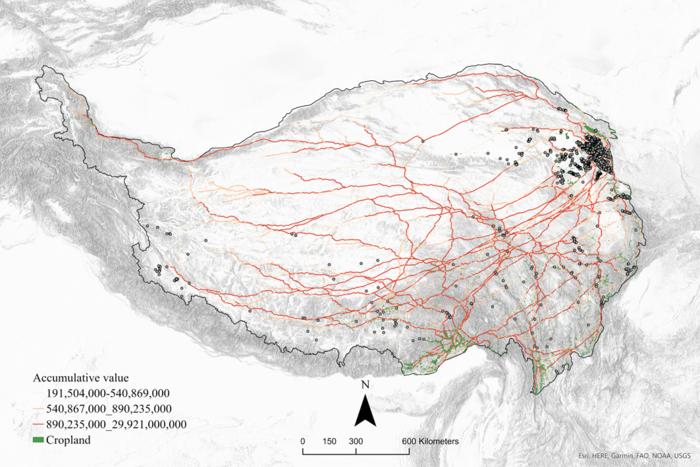
The researchers used advanced geospatial modeling to compare environmental and archaeological evidence that connects ancient mobility and subsistence strategies to cultural connections forged among farmers and herders in the Bronze and Iron Ages. Their findings show that these strategies influenced the settlement pattern and the transfer of ceramic styles — such as the materials used, characteristics and decorative features of the pottery — among distant prehistoric communities across the plateau.
The research was an enormous undertaking made possible thanks to advances in geospatial data analysis and high-resolution remote sensing, according to Michael Frachetti, a professor of archaeology in Arts & Sciences at WashU and corresponding author of the study.
First, the researchers generated simulations of the optimal pathways of mobility used by prehistoric farmers and herders based on land cover and capacity of the environment to support the needs of their crops or herds. For example, highland herders typically move across zones with rich grass resources toward the more limited arable niches on the plateau. Repeated patterns emerging from these simulations were shown to statistically correlate with the geographic location of thousands of prehistoric sites across the Tibetan Plateau.

To test how these routes may have affected social interaction, the team compiled a large database of published archaeological findings from Bronze and Iron Age sites throughout Tibet and generated a social network based on shared technologies and designs of the ceramics found in these sites. The resulting social network suggests that even distant sites were well connected and in communication thousands of years ago across the Tibetan landmass.
“When we overlay the mobility maps with the social network, we see a strong correlation between routes for subsistence-oriented mobility and strong ties in material culture between regional communities, suggesting the emergence of ‘mobility highways’ over centuries of use,” Frachetti said. “This not only tells us that people were moving according to needs for farming and herding — which was largely influenced by environmental potential — but that mobility was key for building social relationships and the regional character of ancient communities on the Tibetan Plateau.”
Their findings also revealed an interesting caveat: The western part of Tibet did not match these patterns as well as the east. According to the authors, this suggests an alternative cultural orientation toward Central Asia, where similar mobility patterns connected prehistoric communities to the west. These east/west differences have been observed in other archaeological studies, they said.
“Archaeologists have been seeking to understand how and why ancient human communities build social relationships and cultural identities across the extreme terrain in Tibet for decades,” said lead author Xinzhou Chen, who earned his doctorate from WashU in 2023 and now works at the Center for Archaeological Sciences at Sichuan University. “This research provides a new perspective to explore the formation of human social cohesion in archaeology.”
Bibliographic information:
Chen, X., Lü, H., Liu, X. et al. Geospatial modelling of farmer–herder interactions maps cultural geography of Bronze and Iron Age Tibet, 3600–2200 BP, Sci Rep 14, 2010 (2024), DOI: https://doi.org/10.1038/s41598-023-50556-9
Press release from the Washington University in St. Louis, by


